Earthquakes and volcanoes.
Three static maps for printing or displaying in class, using the same Equal Earth projection and source records as the interactive map.
Where do earthquakes happen?
A black-and-white worksheet: pupils use the earthquake pattern as evidence to draw where they predict plate boundaries might be.
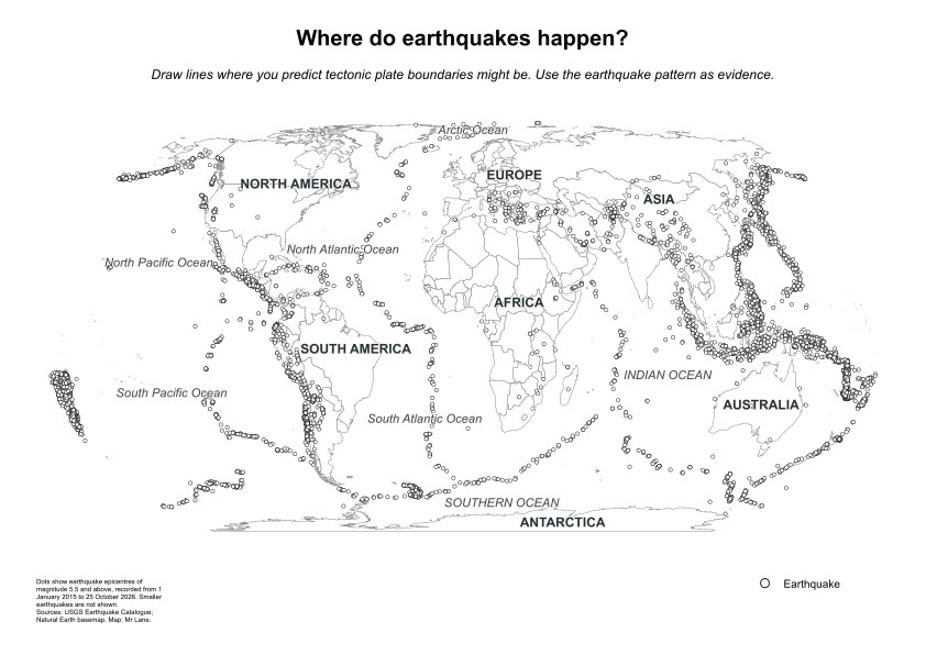
Landscape format. Choose the matching paper size and print at 100% / Actual size.
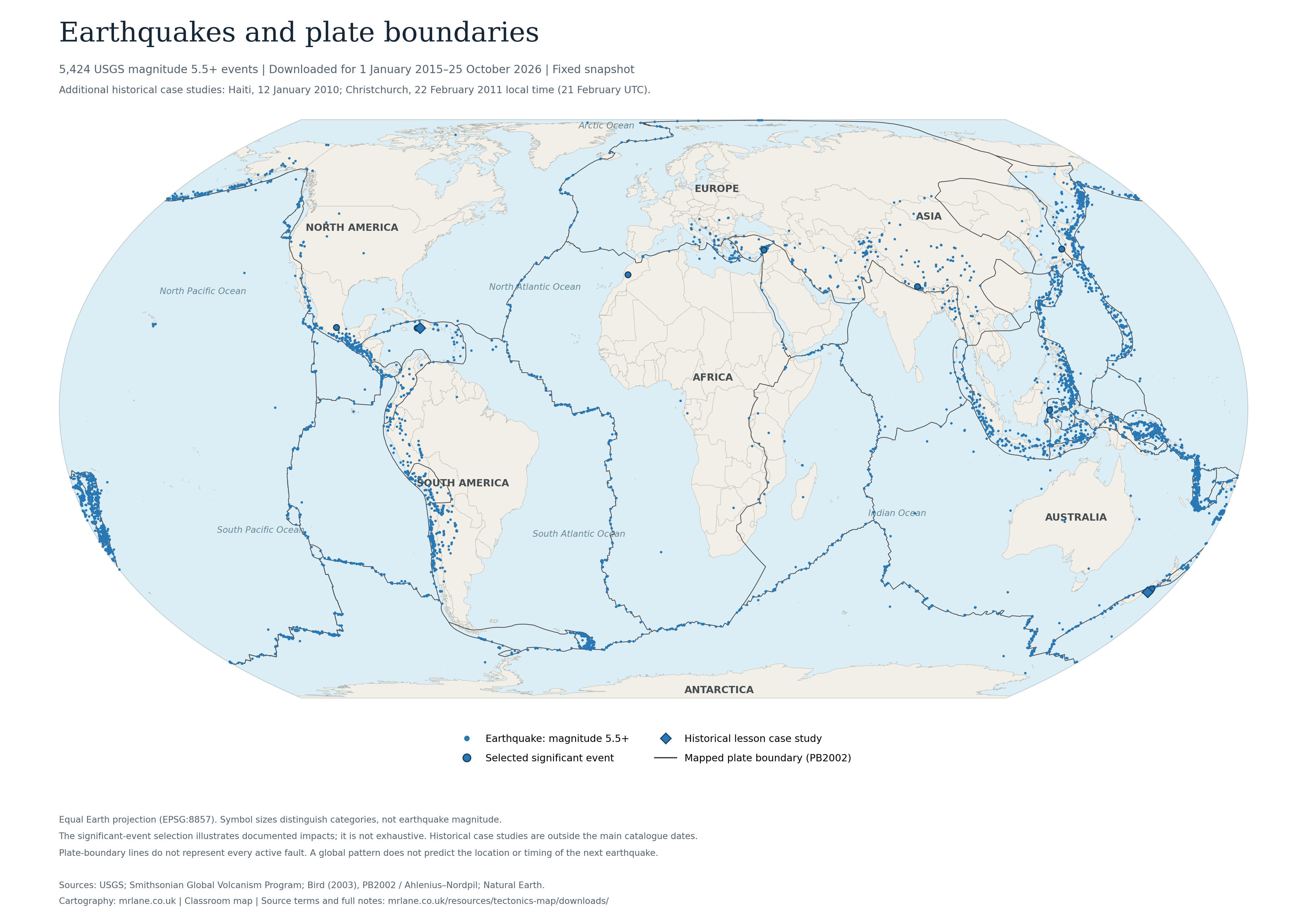
Earthquakes only
5,424 USGS magnitude 5.5+ events for 2015–2026, plus Haiti 2010 and Christchurch 2011 as additional historical case studies. Plate boundaries are retained for reference.
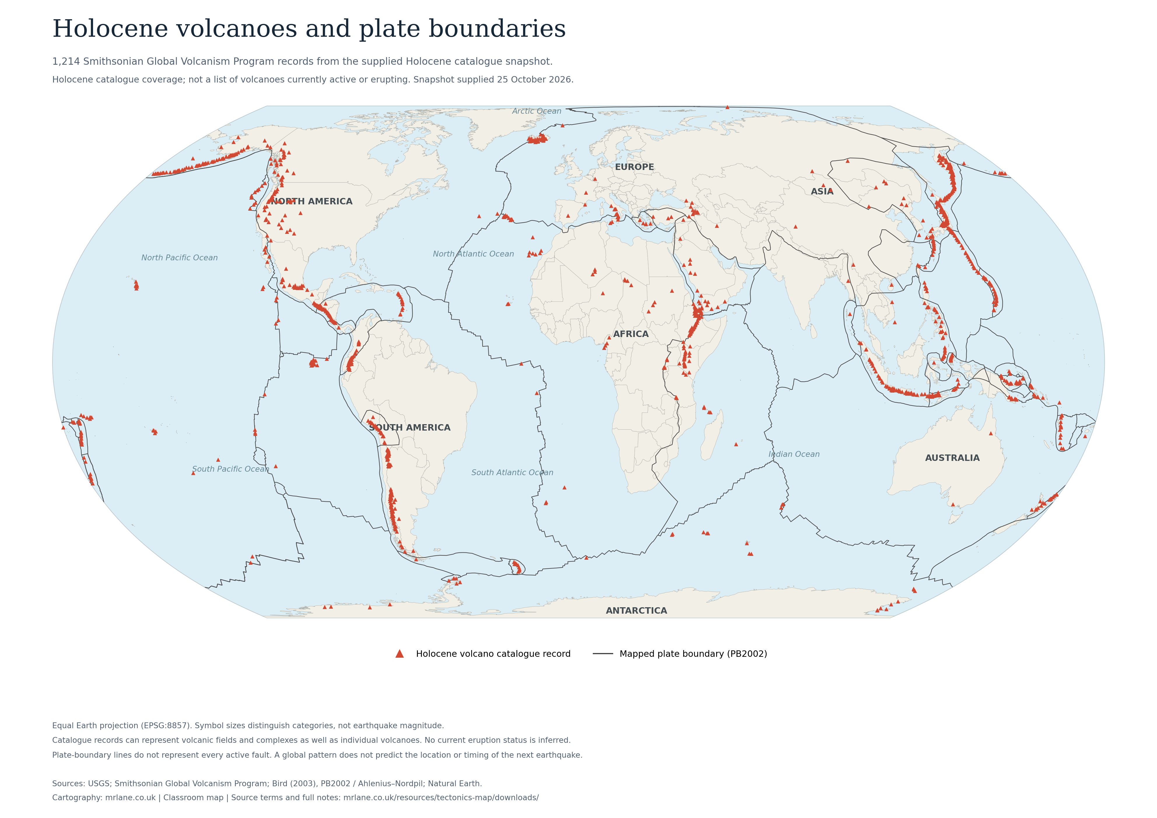
Volcanoes only
1,214 Smithsonian Holocene volcano records. These are not all currently active or erupting. Plate boundaries are retained for reference.
Earthquakes and volcanoes together
Both datasets, with plate boundaries, selected significant events and the two historical lesson case studies.
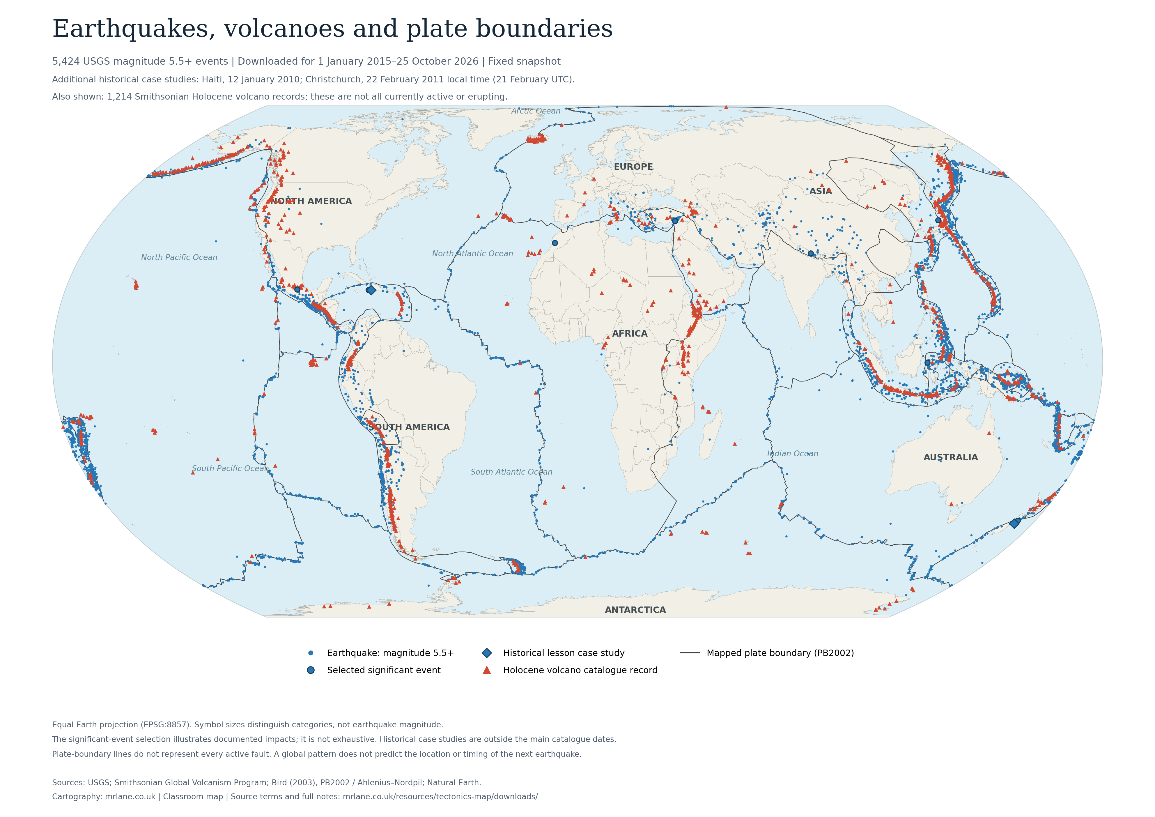
PDFs are A3 landscape and can also be scaled to A4 in your printer settings. The PNGs are suitable for classroom screens. Both formats include keys, coverage notes and source credits.
Sources and map notes
Earthquake catalogue
U.S. Geological Survey: 5,424 events of magnitude 5.5 and above, downloaded for 1 January 2015–25 October 2026. This is a fixed snapshot, not a live feed. Two historical lesson case studies are additional records: Haiti (12 January 2010) and Christchurch (22 February 2011 local time).
USGS catalogue · USGS copyrights and credits. USGS-produced data are generally in the U.S. public domain; third-party material may have different terms.
Volcanoes
Smithsonian Institution, Global Volcanism Program: 1,214 records from the supplied Holocene catalogue snapshot. A catalogue entry does not mean that a volcano is currently active or erupting. “Last known eruption” is a catalogue field, not a current activity alert. The exact downloaded catalogue version was not supplied, so no version number is inferred here.
Global Volcanism Program · Smithsonian terms of use. Do not assume that every Smithsonian dataset is CC0. Unmarked content has usage conditions. These educational maps retain source attribution; no raw volcano-data download is offered.
Plate boundaries
PB2002: Bird, P. (2003), An updated digital model of plate boundaries, Geochemistry, Geophysics, Geosystems 4(3), 1027. Paper and model. GIS distribution: Hugo Ahlenius / Nordpil, tectonicplates, Open Data Commons Attribution License 1.0. The supplied linework is retained.
Basemap and software
Made with Natural Earth 1:50m geographical data (public domain). Prepared in QGIS and exported with qgis2web; displayed with OpenLayers and Proj4js. Equal Earth projection, EPSG:8857. Cartography and teaching presentation: mrlane.co.uk.
Distances and interpretation
boundary_m and boundary_km are the supplied distances to the nearest line in the mapped plate-boundary dataset. They have not been recalculated. They are not distances to every active fault or to an earthquake’s underground rupture.
The supplied median is 59.35 km for all 5,426 earthquake records, including both historical case studies, and 178.65 km for the 1,214 volcano records. These describe this sample and this boundary model; they do not establish a universal threshold or directly compare equivalent time windows. Hiding layers does not change these recorded medians.
Depth was not included in the export and is not displayed. The USGS dmin field is not used as a substitute for depth.
Selected events and Wikipedia
Ten earthquake records have been selected for documented impacts, including the two lesson case studies. This is an editorial selection, not a complete list of damaging earthquakes and not a classification based on the USGS sig score. significant_event and lesson_case_study are separate fields.
Volcano Wikipedia links were matched by the exact Smithsonian GVP identifier using Wikidata P1886, requiring a unique English article, then checked with the English Wikipedia API on 25 October 2026. There are 968 confirmed links; the remaining 246 are blank. This is a conservative identifier match, not a name-based guess. Wikipedia is additional reading; source records remain linked.
Christchurch: the supplied USGS record is 21 February 2011 at 23:51 UTC, equivalent to 22 February locally, and lists magnitude 6.1. GeoNet lists Mw 6.2; ML 6.3 is also widely reported. These estimates use different magnitude measures and/or solutions. The map preserves the USGS source value.
Reuse
Source conditions differ. USGS and Natural Earth public-domain material, the PB2002 GIS distribution’s attribution licence, and Smithsonian usage conditions must not be combined into a blanket “open data” claim. Static map downloads are provided for classroom use with credits. For raw data, follow the original source links and their terms.